Experts Baffled to Find 1,000-Year-Old ‘Lost City’ of Khmer Empire Hidden Beneath a Forest
 Experts Baffled to Find 1,000-Year-Old ‘Lost City’ of Khmer Empire Hidden Beneath a Forest
For centuries, dense jungles concealed the remnants of civilizations that once thrived, their stories buried beneath layers of earth and vegetation. Advances in technology allowed experts to look through the thick canopy and reveal lost cities. A new study published in the journal Antiquity revealed a detailed analysis of the radar detection of ruins identified to be the capital of the Khmer empire, called Mahendraparvata. The lush vegetation of the forests often hid ancient urban networks that suggested complex levels of organization that were previously unknown. This could reshape the knowledge of medieval societies and the rise and fall of old kingdoms.
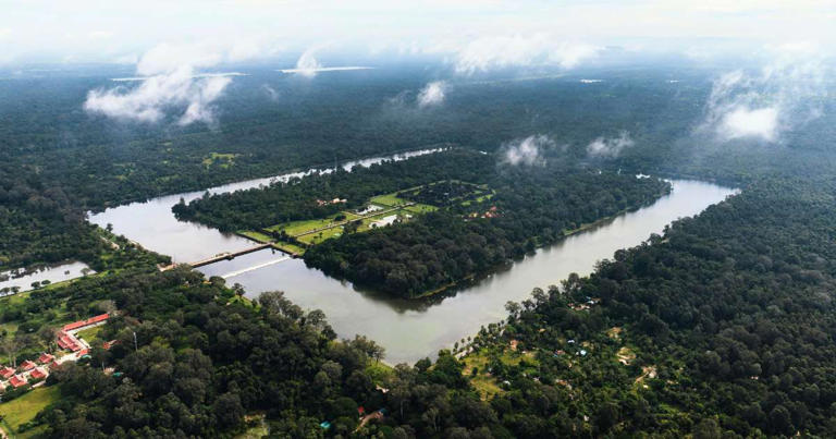
Ancient stone inscriptions narrated tales of a city called Mahendraparvata which was one of the first capitals of the Khmer empire. It reigned in Southeast Asia between the ninth and 15th centuries, according to LiveScience. The city was believed to be hidden beneath the forests on a Cambodian mountain, not far from the temple of Angkor Wat. A collaborative effort between the EFEO, the Archeology and Development Foundation in the U.K., and the APSARA National Authority initiated an airborne laser scanning with ground surveys and excavations. This revealed a detailed map that built the narrative of the ancient city’s development and demise.
Knewz.com noted that archaeological evidence of this lost city was previously restricted to a few isolated shrines. However, the new data identified an “extended urban network” which was dated from the 9th century AD, of the city of Mahendraparvata. The lidar scans identified a massive centrally planned urban area that spanned around 15.4 – 19.3 square miles on the plateau. The city of Mahendraparvata represented the first large-scale “grid city” built by the Khmer Empire, with a central zone and subdivided city blocks, as per Ancient Origins. The city also predated the famous temple complex of Angkor Wat in northwest Cambodia, which was ruled over by King Jayavarman II.
“The mountainous region of Phnom Kulen has, to date, received strikingly little attention,” the researchers wrote in the study as reported by ScienceAlert. “It is almost entirely missing from archaeological maps, except as a scatter of points denoting the remains of some brick temples,” the study added, led by first author and archaeologist Jean-Baptiste Chevance from the Archaeology and Development Foundation in the UK. The research effort lasted years as they commenced a series of Lidar survey flights above the region. Newly detected archaeological features were added to the map that escaped notice due to centuries of encroachment by nature.
Scientists previously hypothesized that the ancient city was located on the plateau, north of Siem Reap, according to MailOnline. It was believed that the area was scattered with landmines leftover from the Khmer Rouge, who occupied the Phnom Kulen from the early 1970s until the late 1990s. Other discoveries included evidence of a royal palace and a state pyramid-temple, two infrastructures typically found in Khmer Empire capitals. “The work effectively draws to a close 150 years of archaeological mapping work in the Greater Angkor region and sets the stage for more sophisticated spatio-temporal modelling of urban form,” the study added.
Source:MSN